New progress on mapping China forest aboveground biomass through integration of multiple datasets
Mapping spatial variation of forest aboveground biomass (AGB) at national or regional scale is important for estimating carbon emissions and removals and contributing to global stocktake and balancing the carbon budget. With the implementation of national ecological restoration projects, the forest area in China increased rapidly since the 1980’s. According to the 9th national forest inventory results, the forest area of China reaches 220.45 million hectares, with the forest cover being 22.96%. Recently, several forest AGB estimates have been produced for China using forest inventory, ecosystem model or remote sensing, yet significant discrepancies remain in both AGB stocks and density. It is therefore necessary to accurately estimate the spatial distribution and variations of the forest AGB to obtain a clearer understanding of carbon dynamics against the background of China’s 2060 carbon neutrality pledge.
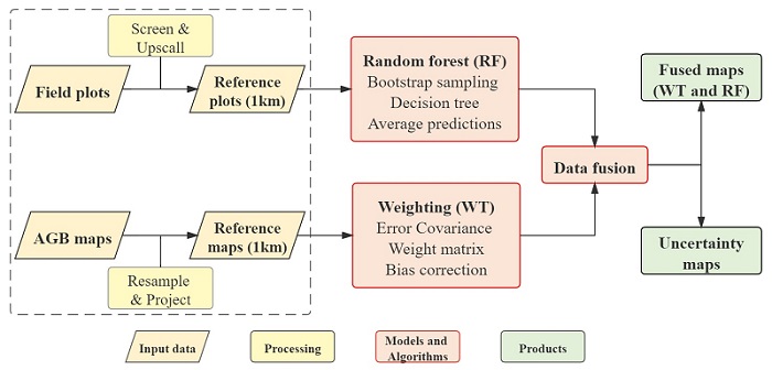
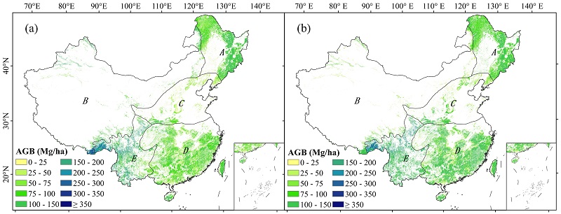
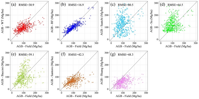
Under the guidance of Professor Yan Junhua and Professor Wang Ying-Ping, Chang Zhongbing from South China Botanical Garden of Chinese Academy of Sciences, collaborated with Sanaa Hobeichi from University of New South Wales initiated a research on mapping China forest aboveground biomass through integration of multiple datasets. The researchers applied two different approaches, an optimal weighting technique (WT) and a random forest regression method (RF), to develop two observationally constrained hybrid forest AGB products in China by integrating multiple dataset (e.g., forest inventory, field measurement, and remote sensing). The forest AGB stock in China was 7.73 Pg C for the WT estimates and 8.13 Pg C for the RF estimates. Evaluation with the field measurements showed that the two hybrid AGB products had higher accuracy with lower RMSE. The results of this study could be used for assessing the future carbon sequestration potential of China's forests and serving the goals of carbon neutrality.
The relevant research entitled “New Forest Aboveground Biomass Maps of China Integrating Multiple Datasets” has been published in Remote Sensing. This study was supported by the National Science Fund for Distinguished Young Scholars (41825020), the Strategic Priority Research Program of Chinese Academy of Sciences (XDA05050200). For more details, please refer to: https://www.mdpi.com/2072-4292/13/15/2892

Figure 1. Flow chart of procedures estimating forest aboveground biomass (AGB)

Figure 2. The distribution of forest AGB maps derived using the (a) WT and (b) RF approaches.

Figure 3. Scatterplots of the validated field
AGB (x-axis) and estimated AGB (y-axis) of the (a) WT and (b) RF approaches and the (c)
Saatchi, (d) Su, (e) Baccini, (f) Santoro, and (g) Huang maps.
File Download: